Great Yarmouth History
A Different approach would correct the Economic disaster we face
SECTION 1
multimedia
History
front
page of the multimedia history of great yarmouth
Guided
Tour of Great Yarmouth History
The
Complete Rows of Great Yarmouth
Index
to all the main characters and places in Great Yarmouth
History
The
Histories and Historians of Great Yarmouth
Leonard
Ley's Memoirs
SECTION 2
Palmer's Perlustration of Great Yarmouth
SECTION 3
The
Revised History of Great Yarmouth
Family
History
One Hundred Years of General Practice
SECTION 4
Fact
or Fiction?
Newtons
error lead to failed physics
Einstein
incredibly incorrect
Descartes
philosophy stands firm
Halleys
comet proves copresumy
Gallileo
Huygens
Laplace
Robert
Hooke, harangued not hopeless
SECTION 5
The
Reality of Life on Earth
Darwins
theory has missed its links
copresumy
proves the big bang impossible
SECTION 6
The
new physics
Coresumy
the cosmic pressure gradient
Other
moons and the sun show copresumy
Diagrams
of the action of cosmic pressure upon the sea
The
truth about the tides and copresumy
The
sea the atmosphere and copresumy
SECTION 7
God
in the copresumy of the Universe
Homelessness in the UK, an original study on attitudes to the homeless.
At around 500,000BC, at the site where now is standing the town of Great Yarmouth, there was a river running from the (current) Midlands through a 150-foot deep valley between rolling chalk hills. This river ran East across countryside where now is the North sea. At that time Neanderthal and modern man coexisted and there was no modern agriculture. No archaeological evidence has been found here from that age, being too deep, but the geology is known from an 19th century borehole made for Lacon’s brewery. Being a brief warm period, the ice came down from the North to cover this area, and as it ebbed and flowed, sometimes up to two miles thick across Scotland and Scandinavia, it ground away the rock beneath, forming sand and gravel. As the ice at times melted away, the melt water carried the sand and gravel across this part of East Anglia, filling up the valley in the chalk to leave a flat sand surface.
In 125,000BC, there was a prolonged interglacial period, and the area around Yarmouth was a sandy moor with elephants and deer forests. This land surface was just above the current sea level, and by digging at Corton at the base of the cliff there can be exposed very easily, a peat layer containing bones and beetle shells, seeds and other remains. This layer is also evident at East Runton, where an elephant’s skeleton, including its very long tusks was recently excavated. The peat is from time to time exposed by cliff falls. At Great Yarmouth this layer has not been demonstrated, but has not been dug down for. The pipe trench up Nottingham way went down 5 metres, and reached undisturbed glacial moraine, showing that the sea had not disturbed the area of the town after the ice finally melted in 10,000 B.C., but lower levels were not penetrated.
10,000 B.C. was the end of the ice age. The North Sea was dry land right across, and in 6,000 B.C. Maglemose man settled in East Anglia, Britain was continuous with mainland Europe. There was a lake where now is the North Sea, that gradually filled and eventually broke through the land between the white cliffs at Dover and Northern France. In about 5,000 B.C. Britain was finally separated from European mainland as North Sea flooded and the icecap receded to present size.
4,000 B.C. brought the Copper Age. The area around Yarmouth was densely populated for those times. Copper tools have been discovered at Gorleston at more than one site, and there are displays of some at the Tolhouse Museum. There are millions of stone tools in the fields around Yarmouth, found easily in many fields at Gorleston and at Caister. Early field systems in evidence, with aerial photography in the dry summer of 1996 showing the whole area to have been intensely farmed from prehistoric times. There are many surviving hut sites, none of which have yet been excavated, but are clearly demonstrable. Trade links were in place with Europe at an early date, and the wider area is rich in prehistoric finds.
In 55 B.C. Julius Caesar made the first Roman expedition to Britain. In 43 A.D. there was a Roman invasion of Britain (Claudius), the first Roman Governor being Aulus Plautius. In 60 A.D. Boudicca and the Iceni rebelled. Tribesmen from this area were likely involved as this was a major grain-producing region. By AD100 the Roman presence would have been felt in the Yarmouth Area. In 250 Caister Roman fort was established, and in 270 AD Burgh Castle constructed. To have two such forts so close seems notable at the least. There was a river available leading to the hinterland, and a major food supply. Likely the grain could feed the troops and surplus be exported to troops in Europe. Defence of the food supply of the Roman army seems the most plausible explanation of this massive presence. The river ran out to the North of the current town of Great Yarmouth, at the site of the little Roman Catholic Cemetery on the Caister road. (later called Grubb's Haven) Somehow the river became diverted to the South, and the excavation for the sewer pipe at South Quay showed a man made quayside backed by a clay lining that could indicate diversion of the river for a Roman harbour, but insufficient work has been done to make this more than speculation. Roman pottery was found at the deepest level excavated at Blackfriars, and Roman roof tiles were found inside the base of the town wall at Alexandra Road. Far too little excavation to deep levels has been done to know what this means, but again the pipe trench in Nottingham way showed that the sand deposit was undisturbed since the ice age, with a burned land surface above it, the date of the earliest occupation being unknown.
In 630 Fursey established his monastic cell somewhere in this area, and we can confidently say from the archaeology that it was not at Burgh Castle, where only Roman remains were found. Yarmouth certainly was at least a Saxon settlement of some size, and in 1002 Sweyne the Viking invaded East Anglia. From the carbon dates at Fullers Hill, and recorded history of Norwich, the wooden and straw structures of the sizable town of Great Yarmouth were in 1010 razed by Vikings. The burned layer of the Saxon town lies across a large area, from Nottingham way to Fuller’s Hill.
In 1041 Yarmouth was in possession of Edward the confessor, having 70 Burgesses, and from this period there is recorded history. In 1101 Archbishop De Losinga of Norwich founded St. Nicholas Church on a site occupied by the Church of St Bennet before it. Some archaeological evidence of that may well remain beneath the present church.
Yarmouth was popular with Monks, and in 1204 the Blackfriars founded a monastery to the South East of the settlement. Later there were monasteries established by the White Friars on North Quay and another by the Grey Friars on the South Quay. Money flowed to the Church then. There was a priory attached to St Nicholas Church, and the Town Hall was established at the Church South Gate. In 1209 was the first Charter for the town, of King John, and in 1261 Licence was granted by Henry II to build a wall, which inevitably encircled the church and the monasteries, and established gates at the North and South, and was bounded on the West by the river. There was no bridge, but there was a ferry to cross the river to the Southtown side. There was a little fishing village at Gorleston, and some saltpans at Cobholm.
1278 saw the foundation of St.Mary's Hospital. There was a Leper’s Hospital outside the North Gate, and the ground outside the North Gate was divided into little field plots to grow food.
In the time of Edward I, the town was known to supply herring, and Edwards’s son used a tailor in Yarmouth, and became Earl of Norfolk, and his Royal Arms are seen on the church. The town then was an important port. Edward III built up the navy, and ships and men from Yarmouth fought and defeated the Dutch in the North Sea in 1340 at the Battle of Sluys.
In 1346 the river silted up, Grubbs Haven was still open as well as the main river to the South. The “first” haven was then cut to improve the passage of ships. As the river silted up the only method they had was to cut a completely new channel to the south, until that one silted and they cut another, and so on. These new channels were cut across the South Denes at various sites. Yarmouth was a premier fishing port and a main base for the Navy. These were difficult times, and in 1349 the Great Plague struck. The town was struck by plague over several centuries; the dead were buried outside the walls, and in the base of the “King Henry” (North-East) Tower. There was a charnel house at some time in the precinct of the church, used to incinerate bodies.
In 1382 Richard II paid a Royal visit. He lodged at the Great Hall of the Priory (Priory School). The town wall was still under construction. Perhaps Richard thought the construction should be accelerated, as eventually, in 1396 the wall was completed. Not until 1427 was the first bridge over the Yare constructed. Later that century, in 1450 foundations were laid for Caister Castle, which was owned by Sir John Fastolf, who also kept a house on the Hall Quay. He was rewarded by the King for successful campaigning in France at Crecy and Agincourt. In1469 Caister Castle was besieged, after the Paston family inherited from Sir John Fastolf, and there was much subsequent wrangling over the estate.
Several breweries were established at North Quay and Fullers Hill, later owned by the Wards, Meadowe, Browne and others.
The river had long been blocking up. It would have been commercially important since the Bronze Age or earlier. Small boats at that time had no difficulty in trading metal, grain and other goods. When the Romans came they must have needed the river more than ever. The side of the river at the pumping station and the building of the town hall has revealed ancient Quay headings, but the date of the timbers could not be ascertained. When the pipe trench was dug with deep pits either side of South Quay, there was a huge deposit of clay that lined the river inside of the timbers to prevent erosion into the sand. At what date this was constructed is unknown. Surely much later than those features, having started in 1508, by 1529 the town had cut its 5th Haven, a new outlet into the sea beyond the South gate, in an attempt to keep the river flowing.
Royal visits have been few and far between, the most famous being perhaps that of Charles I (1671), but in 1515 there was a Visit by the Queen of France.
Famine in previous centuries was a regular problem, and in 1528 there was famine and rioting. By whatever means the town pulled through, and faced the threat from Spain. The town was inspected and a plan drawn up for its fortification. It was very much a target with great naval importance, the fleet being stationed in the Yarmouth Roads. Victualling the fleet was an important trade. Many became rich or made a living from the supply of the fleet. The town was to be fortified. In 1544 a huge Rampire upon the wall was created. Some small remains of that can be seen today. This was a platform built up outside the new gate to take a gun battery. Other work included strengthening the inside of the wall by building up against it to a depth of many feet with millions of tons of earth and sand. Any houses nearer to the wall than the west side of King Street were ripped down. Meantime the river was rapidly silting up. With no such thing as a dredger, the only recourse was yet again to create a new opening across the South Denes, and this entered the Sea much in the position of the current power station. This sixth haven was completed in 1549. The same year saw Kett's rebellion take place at Norwich. John Eachard and two other Yarmouth Burgesses went to London to report the matter to the King.
Fifty years later, in 1550 there was another outbreak of Plague. This must have played havoc in a small unsanitary seaport such as Yarmouth, with ships in and out of harbour, the quays and streets scurrying with rats. The sewage ran in open drains in the narrow rows, or was ferried in carts to the North and South Muck Heaps that were outside the gates by a short distance only. The population of rats must have exceeded the head of population many times over.
In 1555 Henry Manship junior, was born. (1555-1625) Manship the younger was to become an important local historian and was to build upon the work of his predecessor Thomas Damet, documenting the first important written history of the town. His father, Manship senior was a leading figure and arranged the work to construct the Seventh Haven, completed in 1560, that finally was well enough engineered to stand the test of time, so that we benefit from that same harbour entrance today.
An amusing incident occurred in 1578 when Scroby island was annexed to the town.It had been fully dry for a couple of years and grassed over. It was thought that it would remain dry land and be useful to build upon. Needless to say the weather only had to change and soon enough the “island” was once more under water, making those involved look as foolish as they truly were.
There had long been an important market in the town, and it appears to have been on its present site from the very earliest times. Little archaeology has been done, but livestock have been kept and sold there from early times. One of the important feaures of the town was the permanent stall or market cross, of which there were two, but in 1604 a third market cross was erected, showing that trade was booming. It was a cold period of weather followed, and in 1607 The rivers were all frozen solid for three days, something rarely recorded.
Mayors have generally been held of high regard in the town, and their names have been placed on record. The office of Mayor has however remained controversial, more than once been discontinued, and in 1688 the office of Mayor was abolished. It remained so, to be restored in 1702 by a Royal Charter. (Queen Anne).
Fishing has been the mainstay of Yarmouth’s economy. In 1702 a Fisherman's hospital was erected to care for old and destitute fishermen. In the Middle Ages, the fishing in Yarmouth was all important. Herring was a staple in the diet, and had the great benefit of being well preserved in salt. Thus herring was stored and transported by the barrel all over the country. Edward I, whose bust was displayed high inside the roof of St. Nicholas Church, ordered 18,500 herring for consumption by his household in 1300 when he stayed at Stirling Castle, and he showed his love of this fish still further by requesting twenty-four pasties of herring in return for the grant of a lease at Carlton. During the next century, Margaret Paston bought a horse load of herring for four shillings and sixpence, and complained to her husband that “that is all I can get at the moment.” Herring was dispersed far and wide from the town, and aside from brewing and the cloth and woollen trade, seems to have been the greatest source of income for the populace. Herring was sent in 1755 to such diverse places as Naples, Venice, Genoa, Ancona, Trieste, Bordeaux and of course throughout Britain also. Over the years there were tremendous ups and downs in the success or otherwise of the catch. Much of the town itself was devoted to fishing, and the ropewalks were retained inside of the town wall until 1678. There was a lack of warehousing, and goods that could be traded in the open air were few. More perishable produce such as wool was moved straight from one ship to another, whilst herring was dealt with immediately upon landing. John Andrews whose house still stands on South Quay, was the most prominent fish tradesman in the 18th. Century. He owned twenty fish houses and six malt houses in 1741. The fishing then as always was unreliable. Some years had a glut of herring, and others were so poor that there was scarcely a living to be made. As an example, there were 7.5 million herring cured in 1760, and 9.2 millions in 1780. This contrasts with the glut in 1756 of nearly 73 millions, and 57.6 millions in 1773. At the end of that century the trade with Norwich in other consumables was dwindling, but there was a substantial Naval presence in the town due to the French wars, which caused a huge number of extra persons to be billeted in the town, and trade was developed supplying the personnel on shore and the naval vessels in the roads. The navy was stationed in the town from 1796-1811. Further business in regard of shipping was in terms of the construction of new vessels, by example there were 19 new vessels built in 1790, with a total tonnage of 2028, and as many as 44 were built in 1796.
In 1709 Peter Le Neve the historian, purchased a residence in King Street. He had contracted tuberculosis, and whereas he had inherited an estate near Norwich, the sea air had been declared healthy and was fashionable as a cure for ill health. He was responsible for much of the research that enabled the subsequent compilation of Blomefield’s “Norfolk”. A few years later, in 1716, Henry Swinden was born. Swinden mapped the town in amazing and most accurate detail. He also wrote a detailed history, published after his death by his young friend the antiquarian, John Ives junior.
Life was becoming slowly a little more civilized, and 1729 the pillory was removed from the market place, thus ceasing public abuse of minor miscreants. People were more aware of their fellows in general and when in 1766 a severe famine struck the town that would clearly have caused the death of hundreds, several more well to do, led in particular by John Bell the lawyer, paid and raised money by subscription for bread to be distributed.
Water in the town was for centuries obtained from a few public wells. As time went by hundreds were sunk in yards all round the town. Wells would have been easy to sink in the sand, and were a ready water source due to the river on one side and the sea on the other. There is a constant water table at only around 30 feet down. One such well was documented as sunk in a yard behind the dwellings at 53, 54 and 55 King Street in 1776.
Politically Yarmouth has had its moments, with its deep involvement in the regicide of Charles the first, and being slightly involved at least in Nelson’s domestic difficulties by hosting him and the Hamiltons in 1800 when Emma was some 7 months pregnant. Earlier, in1795 the Princess of Orange likewise arrived in England via Yarmouth, which as ever provided an easy sea route from the continent..
The town was until around 1830 confined between the river and the wall. Many other towns have had medieval Rows. It is not a unique feature as some would suggest. Towns such as Leeds have likewise had narrow passages with multiple small dwellings crowded with small dwellings. Few may have been quite as confined as Row 95, but the feature of narrow medieval rows is far from unique. Indeed medieval London before the great fire was built likewise. Where Yarmouth was unusual was that it continued to have that pattern unbroken to such a late date. It was not until 1804 that the rows, more than 150, were first numbered (145 plus half rows). Medieval strips for land ownership were present between the three main streets and these were progressively subdivided. When the rows were numbered a group of persons to do the task assembled at the North Gate most likely, then walked up and down, progressing south with a pail and whitewash, painting up the numbers on the walls. Despite the existence of a map, no planning was used to determine the numbering.
A year later, Yarmouth’s most important and prolific historian, a man who shaped much of the town outside the walls, Charles Palmer, was born. Meanwhile the destruction of famous medieval landmarks accelerated, being marked by the demolition in 1807 of the North Gate. In 1812 the South Gate was demolished. One day the North and South Gates ought to be recreated as a statement for the restitution and preservation of this important medieval seaport.
Napoleon remained a threat, and whilst Martello towers and forts were built on the south coast, Yarmouth was felt to be good for the sea air, to recover health and was a sensible distance from the action. In 1811 St.Nicholas Hospital was built for the benefit of sailors injured in the war with France. The town continued its modernization, and the rows were too narrow for modern commerce. Some wider Streets were needed and in 1813 Regent Street constructed.
In 1813 William III landed at Yarmouth, on his way to London. The same year social reform continued with the last local hanging. (John Hannah) Yarmouth continued as a rich and important place perhaps just starting to decline from the withdrawal of the provisioning of the fleet. To mark the town’s importance, in 1814 a Grand Dinner was held upon the Quay, tables stretching all the way from end to end. Equally a statement was made by the erection on the South Denes in 1817 of the first column to celebrate Nelson’s life and victories. This monument was then visible for miles around, painted famously by J M W Turner, and preceded the building of a similar column in London by several years. One of Nelson’s seamen by the name of Sharman, tended the column and admitted visitors to climb up the steps inside it. The town being quite a spectacle, George IV visited it in 1822.
In the 19th century developments in medical science promoted the need for dissection of corpses. Insufficient bodies were available, although trade in dead bodies was not illegal. Yarmouth was involved with the body snatchers, who raided fresh graves in St Nicholas churchyard at night from their base in Row 6. Travel then was either over the bridge to the south, through Southtown, or to the north, via Caister. The road to Norwich was up the coast and turned west to Filby and thence to Acle. A new road was proposed across the marshes in 1828. Meanwhile, to get to the west side of the Bure there was constructed a new suspension bridge, opened in 1829. The railways were not to reach Yarmouth until the Norwich to Yarmouth line was opened with its terminus at Vauxhall, in 1844. That year, Paget’s brewery, on the east side of the Bure from the railway station was removed, which enabled the line to run over another suspension bridge, southwards down North Quay and South Quay to the fishwharf.
Sarah Martin of Row 57, who had tirelessly campaigned for prisoners’ rights, died in 1843.
In 1845 the suspension bridge was overcrowded, with hundreds of people enjoying a carnival and water spectacle. The bridge was being used as a grandstand, and it failed to take the weight. Many could not swim, and when the bridge gave way, eighty people were drowned.
The town developed for the new trade in holiday visitors. Transport was now available to the town by rail from the midlands and the north as well as many steamers from London. In 1853 building the Wellington Pier commenced. New hotels were built and a promenade Kimberley Terrace was erected in 1843, as was the Victoria Hotel (now the Carlton). Queen Victoria’s son, Bertie, Prince of Wales, stayed regularly at the Shadingfield Lodge, (first in 1872) when his mistress, Lilly Langtry was on stage at the Royal Aquarium. He had visited the theatre on the 9th June 1881, causing quite a stir. Despite that it closed a year later, but was then rebuilt with the current front. It became a successful theatre in the hands of John Nightingale..The Winter gardens were bought second hand from Torquay in 1903. The Britannia pier, first to be built, had several disasters and was rebuilt several times. The seafront was laid with tramlines in 1901. The Hippodrome circus, one of only two purpose built circus buildings in the country was added in 1903, although it replaced a less permanent circus, Gilbert’s that had been there since 1898. The pleasure Beach complex was built in 1906. The Gem (Windmill) opened 1907, and the Empire Theatre in 1911.The Marina open-air swimming baths were added in 1922, and the boating lake in 1926. Hotels included the Queens Hotel (New Beach), and the Royalty complex was built as a Royal Aquarium and included enormous dining rooms to seat 1000, and so feed the mutitude of hungry visitors. Lord Suffield laid the foundation stone on October 8th 1875, and afterwards the Mayor, Samuel Barker, entertained 100 gentlemen to luncheon at the Town Hall. It opened 5th September 1876. Yarmouth’s holiday trade was then booming, only a century later to run down and fade as a residential trade after the advent of cheap package tours by air abroad, with which the old fashioned and un-modernised English seaside town could not compete. Nowadays, most visitors either make day trips by car or coach, or stay in the many largely self-sufficient holiday camps outside of the town.
The war years had their effect upon the town. Yarmouth was never a prime target, and it was a long flight over the sea from Germany, but when the bombers flew to blitz London and Coventry, their safest route home was to swing east over the North Sea. Yarmouth was the last place to drop any remaining bombs. Many fell into the sea. The town was largely evacuated, women and children being dispersed to the safer countryside. At times local militia used the half empty town for target practice in their exercises. The buildings were already in substantial disrepair and became further dilapidated. Surprisingly little was totally destroyed. St Nicholas church was burned out completely in 1940, and not rebuilt until 1961. South Quay and many Row buildings of great historical worth were bulldozed to make way for the cheap utilitarian flats that were rapidly to become slums themselves. Then in 1971 a further wave of destruction removed many more famous landmarks including Fullers Hill, Lacon’s Brewery, and Laughing Image corner. The latter was all in the name of road improvement, as was the loss of the Methodist Temple and Southtown Station. Likewise have Yarmouth Way and the inner ring road cut a swathe through the old town. New building at that time, such as the Havenbridge House and the Market Gates complex were not in keeping with the medieval town. Fortunately at least some of the old town, and in particular much of the wall and towers remain. Lately an attempt has been made to stabilize the historical basis of the town, and the work on South Quay, and the new buildings in Row 57 are a step in the right direction.
Industry has come and gone in Yarmouth. Trade was for centuries seasonal in nature, with the fishing and the influx of boats and whole families from Scotland. The holiday trade served to complement that, and year round industries such as the Birds Eye factory, and the Smiths Crisp factory have been short lived by comparison. The North Sea oil trade, that sees a relatively small number of vessels in port, has replaced the fishing but there are many small businesses on the sidelines that add to the town’s livelihood. The latest trend is a substantial building programme of relatively large and expensive houses at the periphery, whilst the town center remains somewhat stagnant. Commuters, travel to work in Norwich or further afield, whilst the industries of Yarmouth are unchanged. Whilst there is no great motorway link either to the north or south, it seems unlikely that there will be any more development of the harbour. If this were to happen the town would lose even more of its character, yet the number of jobs for locals would be small. The main problem in the central town remains the decentralization of shopping to big stores in warehouses, and the continued refusal by the council of the necessary upgrading of former holiday hotels and guesthouses that, barred from change to better and more valuable houses and flats, are only economic by being let to the poorest of migrants from elsewhere that promote a subculture of deprivation, and suppress the restitution of the town to its former medieval glory.
The port of Great Yarmouth has been of exceptional importance in the past, and fascinated the historians who lived there and some famous visitors.It is uncertain just how and when the port came into being. There are remains of Roman forts within three miles north at Caister, and Burgh, but it was thought that Yarmouth arose from the sea upon a sandbank as a fishing port in Saxon times. I have elsewhere produced archaeological and geological evidence to show that the land here was firm and dry since the ice ages, and that a substantial settlement there was probably burned down by the Vikings (The Revised History).
In medieval times the port was amongst the most important in the land. King Edward I had Yarmouth herring supplied for his travels to Scotland, and his son Thomas, Earl of Norfolk, obtained garments from a Yarmouth tailor. A generation later, Edward III summoned Yarmouth ships for his navy, and John Perebroune, a Yarmouth man, was Admiral of the North Sea. Yarmouth was honoured by the king for its part in defeating the Dutch at the battle of Sluys (1340). At Agincourt and Crecy, Yarmouth was represented by John Fastolf, who was made rich and successful as a result of the campaigns, and was subsequently immortalised by Shakespeare as “Falstaff”. Fastolf was brought to the forefront of 15th. century history by the survival of the remarkable correspondence of the Paston family, in which he featured.
The port being of special strategic importance, the townsfolk laboured for no less than 150 years to construct an impregnable wall round the north, east and south sides. This was completed in 1396, leaving the west side to be protected by a fort, boom and the river.
The coast was protected by sand banks some three miles out to sea, so that a safe passage existed inshore from the south and the north - the famous Yarmouth “roads”. Sailing ships could weather a storm in the roads with relatively little risk of being driven ashore, and there were no rocks to founder upon. Slipping into the river afforded safe mooring.
Yarmouth had more than a mile of quay side within the river, and splendid houses owned by the merchants who traded with the continent and victualled the naval vessels moored in the roads. The houses of these merchants were erected along the quay, where their owners could keep a close eye upon the crews and the gangs loading and unloading their ships. Several of these men became very rich indeed. As well as trading in wool and cloth, they landed and exported vast quantities of herring which after smoking or salting in barrels, went to Russia and Germany.
Some of the Yarmouth merchants developed a beer trade, and there were no less than sixty four malt houses in the town in the seventeenth century.Every street had public houses by the dozen, there were over a hundred within a town that measured 2,238 yards around the three sides of the wall.
When visiting Yarmouth in 1671, King Charles II described the town, saying that he “had not known that such a place existed in all his kingdom”.
Daniel Defoe visited Yarmouth upon his tour in 1722, describing the place in glowing terms:
"and the town facing to the west also and open to the river, makes the finest quay in England, if not in Europe, not inferior even to that of Marseilles itself.
The ships ride here so close and as it were keeping up one another, with their head-fasts on shore, that for half a mile together they go across the stream with their bowsprits over the land, their bows, or heads, touching the very wharf, so that one may walk from ship to ship as on a floating bridge, all along by the shore side. The quay reaching from the drawbridge almost to the south-gate is so spacious and wide that in some places it is near one hundred yards from the houses to the wharf. In this pleasant and agreeable range of houses are some very magnificent buildings, and among the rest, the custom house and town hall, and some merchants’ houses which look like little palaces, rather than the dwelling houses of private men.
The greatest defect of this beautiful town seems to be that though it is very rich and increasing in wealth and trade, and consequently in people, there is not room to enlarge the town by buildings, which would certainly be done much more than it is, but that the river on the land side prescribes them, except at the north end without the gate, and even there the land is not very agreeable, but had they a larger space within the gates there would, before now, have been many spacious streets of noble fine buildings erected, and as we see is done in some other thriving towns in England, as in Liverpool, Manchester, Frome, etc."
In 1849, while he was writing David Copperfield, Charles Dickens stayed in the town and it featured in the earlier part of his novel. Yarmouth then was bustling with life, with seafarers and ships filling the river. The Scots fishermen came down with their families and furniture and trunks and boxes strapped upon their little yawls, and stayed in the close-packed houses that filled the area between the three main streets. The houses were arranged in the “Rows” as they were called: 150 or so narrow passages running from east to west, many only three feet wide, with an open drain in the centre, along which were ranged the timber-framed and flint-faced houses.
The town became independent in 1209, when a charter of King John created the borough. Being self governing, a large archive of public documents was preserved in the parish church and at the guildhall. Yarmouth was blessed with four monasteries, but all had disappeared by 1725, when the Blackfriars Church and friary were destroyed by fire. If any of the monastic libraries survive, they have not been located, although there is a Psalter in the British Library from the nearby monastic cell at Gorleston. Another illuminated manuscript (a Hebrew text, illuminated upon a vellum roll) in the library of the Rev. Dr. Macro at the vicarage in 1740, is now in the archives of St. Nicholas Church. Huge collections of documents amassed, and remain preserved. There are private and public collections at Yarmouth relating to the town’s history, whilst others have been dispersed to places such as London and Oxford.
The earliest historians could only pass on small numbers of copied manuscripts, and so the scope for peer influence was limited. With the advent of printing however, there was ready access to the work of others, and a current style of historical text was able to develop. Caxton found historical texts to be a ready source for his printing press, and provided readily saleable material for commercial use (laws of copyright were not established until 1709). Caxton thus disseminated the works of the earliest writers, and the process of development of historical writing was greatly boosted. Nevertheless, many early historians were more antiquarian collectors of documents and information than true historical writers, and this only changed with the initiative of William Dugdale who established a style of writing and presentation which prevailed until the twentieth century. How his work influenced others working subsequently on their histories of various towns and counties will be examined in some detail in the main chapters of this dissertation.
The great national historians began with Caxton, who was responsible for taking the French “The Brut”, translating it, and publishing it as the Chronicles of England, in 1480. Leland (1503-1552) had great designs on completing a History of England, collected vast amounts of materials, and made accurate descriptions on his tours, but was unable to complete his task. Sir Thomas More produced his great work, a History of Richard the Third, in 1543, and as the first to produce a truly great text, has not been credited enough. Stow wrote in 1565, A Summarie of Englishe Chronicles. Hollinshed produced the first substantive History of England in 1577.His narrative was dry and dull, and was the work of a syndicate comprising also, Hooker, Stow, Harrison and Stanyhurst.Bale rewrote it, and his work has been much criticised. John Speed (1552-1629, produced his History of Great Britaine in 1611, a year after William Camden's Britannia was first published in English. Camden's work is considered the great achievement of Elizabethan times. It had been written in Latin, in 1586. Dugdale (1605-1686) followed Camden, and developed the techniques of historical writing and presentation to a new level. Sir Henry Spelman (1564-1641) of Narborough in Norfolk, never achieved the same level of prominence in terms of published works, but did produce a description of the county “Icenia Sive Norfolkiae Descriptio Topographica”, and had an influence upon his contemporary William Dugdale, who he corresponded with. County history writing, in general preceded works on specific towns. Stow’s Summarie of English Chronicles (1565) precedes his great work on London by as much as thirty years. Before that the individual county or town history was a rarity.
The seventeenth century saw a great increase in the production of such works, but the printing of very few. Camden led the way, and enormously stimulated interest in county projects. Although his manuscript existed in Latin from 1586, the published history in was not printed until 1610. In fact county surveys began to appear from the beginning of the century, for example, Richard Carew The Survey of Cornwall, 1602; History of Chester 1609, by Robert then David Rogers; then came the influential John Speed’s Theatre of the Empire of Great Britain (1611). In Devon, following Hooker's steps, came Sir William Pole and Thomas Westcote.These three authors all failed to get into print in their lifetimes and much of their work was used by others and printed only centuries later. In Huntingdon, Robert Cotton was collecting material for a history, but even he failed to produce one, though of course the materials that he collected were vast, and provided the basis for the British Museum. Cotton’s materials were the basis for John Speed’s work, and Cotton wrote the piece in it on Huntingdonshire.
The eighteenth century was also a difficult time for authors, when the book trade was heavily centred upon London, paper was scarce and expensive, and the copyright of books was bought and sold as a commodity by a select few.During this period many historical authors had great difficulty in getting their work into print.Those that did, often did all the work themselves. An example of the enterprise shown by such men was Francis Blomfield, who converted part of his house and installed his own press. Nevertheless, despite the difficulty he produced “one of the greatest county histories”, An Essay Towards a Topographical History of the County of Norfolk (1739). Other examples of successful publishing include T.Phillips’ History and Antiquities of Shrewsbury (1779), and Charles Seymour in Kent, with the New Topographical, Historical and Commercial Survey (1776). In Huntingdon there were problems for Benjamin Hutchinson, who attempted a “Natural History and Antiquities of Huntingdonshire” collecting the materials from about 1770 to the 1790’s, but going mad in his attempt.Often work was passed from one historian to another. John Ogilby’s Britannia was a three-volume work on Surrey begun in the 1670’s, but not printed until 1718 by Richard Rawlinson, who came across the manuscript in the Ashmolean in 1714. Similarly Smyth’s and Hutchinson’s manuscripts were for sale, and acquired by John Simmons of Paddington, who advertised them as ready for the press, but could find no takers. They have now been lost, and it is fortunate therefore that in Yarmouth in the same period the work of Henry Swinden passed to John Ives who was in a position to effect publication, for again the original manuscript has long since vanished. The nineteenth century was a period when publication was much more easily pursued. There were many more outstanding successes. Robert Surtees’ Antiquities of the County Palatine of Durham is a notable example, although many counties such as Huntingdonshire, as related above, had no significant written history prior to the Victoria County History (1926-38). In Norfolk, William Worcester (1415-?1482) had gathered material for his itinerary in his travels in around 1470, but again, it came to nothing in terms of a printed work, which did not appear until the publication of Blomefield's history of the county. Nothing of substance followed in Norfolk on a county-wide scale, but town histories such as Hillen’s King's Lynn (1907) appeared. Likewise in Kent, although Ireland’s History of Kent appeared in 1828, it was in large part a reproduction of Hasted’s earlier county history, and the works of substance were the town histories, such as Dunkin’s History and Antiquities of Dartford (1844), and Woodruff’s History of the Town and Port of Fordwich. In Great Yarmouth it was Charles Palmer who brought the earlier histories from manuscript into print, and produced the exceptional work, The Perlustration of Great Yarmouth. As many historians had before, he published his books by public subscription, the profit being insufficient to cover the costs. As if the task of producing the work were not enough, historians have generally had to apply themselves to financing the enterprise, and even to do the work of the printer and publisher. The pursuit of history has seldom reaped any reward. The following chapters will show how the historians were devoted to the task, regardless of the cost, both financial and personal. Successive historians have passed on their materials unwittingly, having been unable to complete their intended scheme. Each successive historian picked up the scheme in his own way. Many historians have set themselves impossible tasks, and failed to complete them. There being no overall scheme and no appointed successor the outcome in such cases has been left to fate.
Charles John Palmer’s Perlustration of Great Yarmouth must surely rank as the finest history of any town ever written. Now this has been completely modernised and brought upto date with the “New Perlustration” or Revised History of Great Yarmouth, with hundreds of maps and photographs.
Charles Palmer's Perlustration was first published in parts, and then in three volumes, printed in 1870, 1872, and 1874. The compilation of events and the history of the families who lived here is so detailed and exhaustive as to defy anyone to match it.
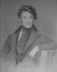
C.J.P.,
aged about 20 years.
Worldwide, to anyone interested in genealogy, the history of their family, having any link to the town, it is invaluable. It is therefore for all those persons not already possessing access to the original, and to revive the interest in it and in Great Yarmouth, that I have decided to republish it in full. At first I thought that a scan of the pages might suffice, and produced it in that form on CDRom, but it was immediately clear that a completely retyped and recompiled version was necessary, searchable in every word and detail. I have meantime been at work on my own new and updated version which has the benefit of modern computer graphics and digital photography. The first volume of this is now also ready for the press. Thus the first volume of both the old and the new will be printed at the same time and supplied in each case with a CD Rom that can be fully searched and used for personal study. I have taken the liberty of adding a few extra notes to Palmer’s book that may be of interest, but the layout and the grammar remains that produced by Palmer, with very little change, I trust. A study of the Victorian English and a comparison with modern American English is interesting, since spellings and word useage that we might think are now Americanised, are actually nearer to the original than much of the language which we now commonly use ourselves. Charles Palmer (1805-88) lived for many years at no.4 South Quay, Great Yarmouth. This house had been re-fronted in Georgian style (white brick) by his father, John Danby Palmer when he first acquired it, and the house survives in that form today. Charles Palmer’s mother was the daughter of Charles Beart of Gorleston. In due course Charles inherited the Elizabethan mansion, but he was quite scathing concerning the vogue of the time for refacing houses with white brick. He absolutely preferred the original, and could see the folly of unnecessary change for fashion’s sake. Internally the house remains full of character, fine carved fireplaces and moulded ceilings. It is reputed to be the place where the deed of execution of Charles I was signed. It seems likely that living there, influenced by the interest of his father in local history, then being articled as a solicitor to Robert Cory, another significant local historian, stimulated his lifelong obsession with local history. Charles was said to have been sickly as a child, and was at first tutored at home by a female governess together with his sister. He later went to Mr Bowles’ school in Queen Street in common with James Paget and other local men of importance. Palmer later gave the opinion that he learned nothing at Bowles’ school. In a similar way, it is obvious that he held women in low regard. His extreme chauvinism comes out throughout his writing. I am led to wonder what his governess was like. He can have had little close contact with his mother Amelia. The only woman he ever commented upon favourably was Mrs. Dawson Turner. His own wife was never mentioned, nor was his sister, and he generally avoids describing women altogether. He is also evidently something of a snob. He mixed from an early age with prominent men in the town such as Dawson Turner and the Palgraves the wealthy Doctor Penrice and the latter’s benefactor, Lord Chedworth. His historical works are copiously full of such people, but he made relatively little mention of such as beatsters, fishermen and fish girls. Palmer’s major historical work was the three volume Perlustration of Great Yarmouth, but his printing of Manship’s work with copious additions, and his Continuation of Manship, unrelated as it is to the original, were very substantial works indeed. He retained thousands of deeds and documents of relevance in his offices as solicitor, and I think that he must have used his secretarial assistance to good advantage. Palmer was a most prolific writer, and indeed the detail in his work is so great as to be scarcely credible of research without modern aids such as computers and copiers. Palmer was well aware that there was no secure archive, and that many important documents were in private hands, frequently being bought and sold by collectors at auction. They could easily be lost or dispersed, and were very difficult to keep track of. Documents of importance had already passed from the locality and were in the British Museum and in the Bodleian Library. Remarkably, although Palmer was well aware of documents in the British Museum, he did not appreciate that there were documents of relevance in the Bodleian Library. His list of sources, written in a substantial notebook, came to light in 1994, and relates to documents held either locally and in the British Library. Palmer’s The Perlustration of Great Yarmouth is probably unique. It follows several works of a very different style that in the main process or reprint old manuscripts and documents and present information but do not break new ground. Palmer follows such substantial historians as Robert Surtees, born in 1779, whose first volume of the History and Antiquities of the County Palatine of Durham, was reviewed in the quarterly review by Robert Southey. Southey was quite in favour of the work, describing it as a “farrago in folio”. Surtees’ work ran to four volumes, printed in 1816, 1820, 1823, and 1840. He had used his predecessors work substantially. Durham history began to be written in 1573-4 by Christopher Watson, a four volume work, now in the Cottonian mss. The first book is an abstract of the lives of the Bishops, the second is a Saxon history, the third and fourth are both poetry and ecclesiastical matters. When Palmer wrote, ecclesiastical items were still very much in vogue. He writes several chapters on the work and family histories of various ministers in Yarmouth. His bibliographical notes suggest that he might have thought of taking such an approach to an even greater depth, since he has included substantial lists of sermons and local ecclesiastical publications. In Durham, history continued in the hands of William Claxton of Winyard, who in 1575 assisted Stowe and Camden. Then Roger Dodsworth was employed by Lord Fairfax and collected one hundred and sixty volumes of papers that are now in the Bodleian. Likewise a Durham barrister, James Mickleton, collected 50 volumes of items. Others continued to transcribe, such as John Rudd, Thomas Rudd, George Smith, Dr.Christopher Hunter, the Rev. Thomas Randal, Thomas Lyll and George Allan. In 1785, Hutchinson published the first of four volumes of his History of Durham . William Hutchinson (1732-1814) was an attorney at Bamard Castle. He first wrote An Excursion to the Lakes in Westmorland and Cumberland and in 1776, A Tour through part of the Northern Counties in the years 1773 and 1774. Richard Gough dismissed the latter as “a hasty crude performance with little information, and in a quaint style”. Palmer in Yarmouth had similar antecedents, collectors of copious materials followed by a similar spread, if rather less a number of historical authors. Palmer brought together an enormous mass of material, perhaps inspired by such as Dugdale, and with many authors attempting likewise in other shires, he strove to be their equal, or to surpass them. His description of the town and its occupants in the Perlustration is exceptional. Many other authors, like Hutchinson in Durham, had written tours of a county or greater areas of the country. The attempt at such a detailed and complete tour within a single town, appears to be unique. A contemporary and friend of Palmer was Dawson Turner (1775-1858). Dawson was the Grandson of the Rev. Francis Turner, master of the Hospital School and minister at St. George’s Chapel, and born accidentally at 40 Middlegate Street in 1775, where his mother was visiting her husband’s uncle. Turner’s bank had been started by his father James at what had been the Three Cranes Public house between rows one hundred and six and one hundred and eight. The business moved to Hall Quay, where the upper floors were used by Dawson Turner as his private residence. At one time Dawson Turner also owned a brewery business and public houses in conjunction with Samuel Paget, father of Sir James, the world-famous physician. I suspect that Turner had no difficulty in predicting the ruin of his friend Paget. In the deeds of no 68 King Street, I found details of Paget’s business, and details of the mortgage that he held with Dawson Turner. Business however went into a steep decline, and in 1831 Paget was paying Gurney, Turner and Brightwen the sum of £6,000 per annum in interest upon a loan of £60,000 with all of Paget’s properties mortgaged to them. Palmer had access to a multitude of sources, yet made less of the contents of the council archive than may commonly have been supposed. He had two additional sources of which he made extremely fine use. Firstly, property deeds. These inevitably related the succession of ownership of the buildings within the town, and so were readily described as he perambulated (metaphorically) on his ‘perlustrations’. The latter was his finest work, being an entirely original idea. Thought by many to be the finest description of any town, it contains descriptions of many of the inhabitants, combined with a description of the streets and rows, the whole being described as though taking a walk around the town. Although as a result it is often rambling, and in no sense chronological, it presents the reader with an extraordinarily in-depth survey of the town, many trades are mentioned, and descriptions are given of the finer buildings, in association with their ownership and the family connections of the owners. It includes considerable detail of the political aspects of the town, concerning the various councilmen, Mayors, Burgesses, Members of Parliament, clergymen and merchants of the town. This does often leave a gap with respect to the common man, his life generally being considered by Palmer to be rather beneath a detailed description of this kind. Nevertheless this criticism should not be taken too seriously. The book is simply an incredible piece of scholarship, now available to you in fully searchable pdf format, here on this website.